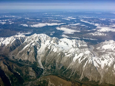
Changbai Mountains
Mountain range, mythical Qing birthplace, source of three rivers.

The Changbai Mountains are a major mountain range in East Asia, extending from northeastern China across the border into North Korea.
- location
- Northeast China (Jilin, Liaoning) and North Korea (Ryanggang, Chagang)
- first_recorded_name
- Sometimes identified as Buxian Shan in the Classic of Mountains and Seas, though
Lore & Background
A magpie dropped a red fruit near Fekulen, who ate it and became pregnant with Bukūri Yongšon.
Reader's Guide
The Changbai Mountains hold enduring significance as a natural and cultural landmark. Geographically, they are the source of three major rivers: the Songhua, Tumen, and Yalu. The range features distinct vegetation zones, from tundra above 2,000 meters to mixed and temperate hardwood forests at lower elevations, and is a habitat for Siberian tigers, Asian black bears, Mongolian wolves, and wild boars. Culturally, the mountains are central to the founding myth of the Qing dynasty, with the imperial family regarding them as their traditional homeland. The mountains' long, cold winters and annual precipitation up to 1,400 mm shape their ecology.
Did You Know?
- The Changbai Mountains are the source of three major rivers: the Songhua, Tumen, and Yalu.
- The range's Chinese name literally means 'Perpetually-White Mountain Region.'
- The Qing emperor Hong Taiji claimed that Bukūri Yongšon was conceived when a magpie dropped a red fruit near the maiden Fekulen, who ate it and became pregnant.
- The Yabuli Ski Resort is located in the Changbai Mountains.
Boundary Between Nations
The Changbai Mountains occupy a position of notable geographic significance, forming the dividing line between China and the Korean peninsula. Situated to the east of the vast Northeast China Plain, they mark where one nation's territory ends and another begins. This boundary role places them at the eastern edge of one of China's broadest lowland regions, where the terrain transitions from flat plains to elevated mountainous ground. The mountains thus serve as both a physical barrier and a geographic marker, defining the eastern limit of the plain that stretches from a narrow coastal strip north of Shanhaiguan all the way up to the crown of the country's distinctive rooster-shaped outline. In a nation where the land generally descends from the western highlands toward the eastern coast, the Changbai Mountains represent a prominent feature at that eastern margin, separating the interior from the peninsula beyond.
The Northeast Plain's Eastern Edge
The Changbai Mountains are best understood in relation to the enormous Northeast China Plain that lies to their west. This plain begins as a narrow sliver of flat coastal land just northeast of Shanhaiguan and then opens up dramatically into one of the country's broadest lowland expanses. It stretches northward to the point where the Greater and Lesser Hinggan mountain ranges converge, a spot that forms the crown of what is colloquially called the "Chinese rooster" shape of the nation. The Changbai Mountains sit at the eastern flank of this entire expanse, capping it off and preventing the plain from extending further toward the sea. Their presence shapes the character of the region, creating a striking contrast between the flat, agriculturally productive lowlands to the west and the elevated, more rugged terrain to the east. This juxtaposition of plain and mountain is one of the defining geographic features of northeastern China.
Among China's Mountainous Terrain
The Changbai Mountains belong to the broader category of mountains that, together with plateaus and hills, cover nearly seventy percent of China's total land surface. Mountains specifically account for thirty-three percent of the country's terrain, making them one of the dominant landform types in a nation of roughly 9.6 million square kilometers. The country's topography is remarkably diverse, encompassing snow-capped peaks, deep river valleys, broad basins, high plateaus, rolling plains, terraced hills, and sandy dunes in countless variations. The Changbai Mountains are part of this rich tapestry of physical geography. While the nation's rugged terrain creates significant challenges for building overland transportation networks and requires extensive terracing to support farming, it also makes mountainous regions conducive to the development of forestry, mineral extraction, hydropower generation, and tourism.
Within the Five Macro-Regions
The Chinese government has divided the country's topography into five homogeneous physical macro-regions, and the Changbai Mountains fall within the broader Eastern China category, specifically in the context of the northeast plain subdivision. This classification system recognizes that the nation's landscape, while unified as a single country, contains fundamentally different physical zones. The general pattern is one of descent: the land is highest in the west, where the Tibetan Plateau and towering massifs dominate, and progressively lower toward the eastern coast. The Changbai Mountains, positioned in the northeast, represent a significant elevation feature at the periphery of this descending gradient. They are part of a country where the exact land area of approximately 9.6 million square kilometers is sometimes contested due to border disputes, and where the interplay between high western plateaus and lower eastern plains creates one of the most varied physical environments on Earth.
Frequently Asked Questions
Who is Changbai Mountains?
Changbai Mountains is a major East Asian range that straddles the border between northeastern China (Jilin and Liaoning) and North Korea (Ryanggang and Chagang). Its most famous feature is the volcanic summit Paektu Mountain, crowned by the caldera lake known as Heaven Lake.
What are Changbai Mountains's powers or role in the region?
The range acts as the headwater source for three major rivers, making it a critical hydrological anchor for the surrounding landscape. Its volcanic geology also gives it a dynamic, ever-shifting character, since Paektu Mountain remains one of East Asia's most notable active volcanoes.
How does Changbai Mountains's story end?
Because it is a living geological system rather than a fixed narrative, the range has no true ending; its most dramatic recent chapter was a large eruption around 946 CE that reformed the summit and created the basin now holding Heaven Lake. Ongoing seismic and fumarolic activity mean the range's geological story is still being written.
Why is Changbai Mountains important to fans of the canon?
In traditional Chinese and Korean lore the range is venerated as the mythical birthplace of Bukūri Yongšon, the legendary progenitor of the Aisin Gioro clan that later founded the Qing dynasty. It also carries practical weight as a shared natural landmark between two sovereign states and as the origin point of three significant river systems.
What is Changbai Mountains's first recorded name and when does it appear?
The name 'Changbai' first surfaces in written records from the Liao dynasty (916–1125) or the Jin dynasty (1115–1234), depending on which source a reader consults. A tentative link to 'Buxian Shan' in the Classic of Mountains and Seas has been proposed, but that identification is not firmly settled in widely accepted canon.
More in Mountain Ranges And Massifs 25-29
Elsewhere in the Mountain Ranges And Massifs universe
Spotted an error? Know more?
This is a living reference — every entry is fact-audited, and reader corrections feed straight into our audit queue. Suggest an edit · See this site's audit record