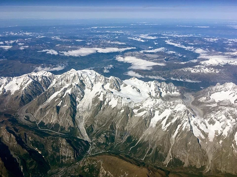
Tian Shan
The Roof of the World, a high mountain junction in Central and South Asia.

The Pamir Mountains are a mountain range in Central Asia and South Asia, located at a junction with other notable mountain ranges: the Tian Shan, the Karakoram, the Kunlun, the Hindu Kush, and the Himalayas. They are among the world's highest mountains. Much of the range lies in the Gorno-Badakhshan region of Tajikistan. Spanning the border parts of four countries, to the south they border the Hindu Kush mountains along Afghanistan's Wakhan Corridor in Badakhshan Province and the Chitral and Gilgit-Baltistan regions of Pakistan. To the north, they join the Tian Shan mountains along the Alay Valley of Kyrgyzstan. To the east, they extend to the range that includes China's Kongur Tagh, in the "Eastern Pamirs", separated by the Yarkand valley from the Kunlun Mountains. Since the Victorian era, they have been known as the "Roof of the World", presumably a translation from Persian.
- Location
- Central Asia (Tajikistan, Afghanistan, Pakistan, Kyrgyzstan, China)
Verified Timeline
Lore & Background
The Pamir Mountains sit at a junction with five major ranges: the Tian Shan, Karakoram, Kunlun, Hindu Kush, and the Himalayas. Much of the range lies in Tajikistan's Gorno-Badakhshan region, but it spans four countries. Since the Victorian era, they have been called the "Roof of the World," likely from Persian. The range has many names: in Shughni it is Pomīr or Pomer Kūen; in Russian, Pamirskiye gory; in Pashto, Pāmīr Ghrūna; in Tajik, Rishta Kūhhoi Pomir; in Urdu, Pāmīr Kohistān; in Sanskrit, Sumeru. In Kyrgyz it is Pamir Tooloru, and in Uyghur, Pamir Ëgizliki. Old and Middle Chinese referred to it as the "Onion Range" (Cōnglǐng), named for wild onions. The term "pamir" is also a geological term for a flat plateau or U-shaped valley left by a melting glacier, used for summer pasture. The three highest peaks in the core are Ismoil Somoni Peak at 7,495 m, Ibn Sina Peak at 7,134 m, and Peak Korzhenevskaya at 7,105 m. In the Eastern Pamirs, China's Kongur Tagh is the highest at 7,649 m. The Vanch-Yakh Glacier is 77 km long, the longest in the former USSR and outside polar regions. About 12,500 km² of the Pamirs are glaciated. The climate is tundra (ET), with long, bitterly cold winters and short, cool summers, and annual precipitation around 130 mm. Coal is mined in the west, but sheep herding in upper meadowlands is the primary income source. Lapis lazuli from Egyptian tombs is thought to come from the Pamir area in Badakhshan, Afghanistan. In 138 BCE, Zhang Qian reached the Fergana Valley northwest of the Pamirs. From about 600 CE, Buddhist pilgrims traveled on both sides of the Pamirs to reach India from China. In 747, a Tang army was on the Wakhan River. In 1602, Bento de Goes traveled from Kabul to Yarkand. In 1838, Lieutenant John Wood reached the headwaters of the Pamir River. From 1871 to around 1893, Russian military-scientific expeditions mapped most of the Pamirs. In 1891, the Russians informed Francis Younghusband he was on their territory (the 'Pamir Incident'). In 1928, the last blank areas around the Fedchenko Glacier were mapped by the German-Soviet Alay-Pamir Expedition. In the early 1980s, a deposit of gemstone-quality clinohumite was discovered. The earliest known evidence of human cannabis use was found at the Jirzankal Cemetery. The Pamir Highway, the world's second highest international road, runs from Dushanbe to Osh. The Great Silk Road crossed a number of Pamir Mountain ranges. In December 2009, the New York Times featured tourism in the Pamir area of Tajikistan; 2013 was the most successful year ever for tourism. Historically, the Pamirs were a strategic trade route between Kashgar and Kokand on the Northern Silk Road. In the 20th century, they were the setting for the Tajikistan Civil War, border disputes between China and the Soviet Union, and establishment of military bases by the US, Russia, and India. Some researchers identify the Pamirs with Mount Meru or Sumeru.
Reader's Guide
The Pamir Mountains are a high-altitude region best explored via the Pamir Highway, the world's second highest international road, running from Dushanbe in Tajikistan to Osh in Kyrgyzstan through the Gorno-Badakhshan Autonomous Province. The range's three highest core peaks are Ismoil Somoni Peak (7,495 m, formerly Stalin Peak and Communism Peak), Ibn Sina Peak (7,134 m, still officially Lenin Peak in Kyrgyzstan), and Peak Korzhenevskaya (7,105 m). In the Eastern Pamirs, China's Kongur Tagh reaches 7,649 m, though some sources count it as part of the Kunlun. The Vanch-Yakh Glacier, at 77 km, is the longest in the former USSR and outside polar regions. The climate is tundra: long, bitterly cold winters and short, cool summers, with annual precipitation around 130 mm. The primary economy is sheep herding on upper meadowlands, with some coal mining in the west. The Pamirs have been a crossroads for millennia: lapis lazuli from Egyptian tombs likely came from Badakhshan; Zhang Qian reached the Fergana Valley in 138 BCE; Buddhist pilgrims crossed from around 600 CE; a Tang army was on the Wakhan River in 747; Marco Polo may have traveled along the Panj River; and Bento de Goes traveled from Kabul to Yarkand in 1602. In 1838, Lieutenant John Wood reached the headwaters of the Pamir River. Russian military-scientific expeditions mapped most of the Pamirs from 1871 to around 1893. The 'Pamir Incident' of 1891 saw Russians inform Francis Younghusband he was on their territory. In 1928, the German-Soviet Alay-Pamir Expedition mapped the last blank areas around the Fedchenko Glacier. The earliest known evidence of human cannabis use was found at the Jirzankal Cemetery. Tourism has grown, with 2013 being the most successful year ever. The Great Silk Road crossed the range, and the Northern Silk Road connected Chang'an with Kashgar over the Pamirs. In the 20th century, the mountains saw the Tajikistan Civil War, border disputes, and military bases. Some researchers identify the Pamirs with the sacred Mount Meru of Hinduism, Buddhism, and Jainism.
Did You Know?
- The Pamir Mountains are known as the "Roof of the World," a phrase likely translated from Persian and used since the Victorian era.
- The Vanch-Yakh Glacier in the Pamirs is 77 km long, making it the longest glacier in the former Soviet Union and the longest outside polar regions.
- The earliest known evidence of human cannabis use was discovered in tombs at the Jirzankal Cemetery in the Pamir Mountains.
- In Old and Middle Chinese, the Pamirs were called the "Onion Range" (Cōnglǐng), named after wild onions growing in the region.
- The Pamir Highway, running from Dushanbe to Osh, is the world's second highest international road.
A Crossroads of Ranges
The Pamir Mountains occupy a remarkable position at the meeting point of five of the world's great mountain systems. Sitting where Tian Shan, Karakoram, Kunlun, Hindu Kush, and the Himalayas all converge, the range forms a kind of continental knot in the heart of Central and South Asia. Much of the territory falls within the Gorno-Badakhshan region of Tajikistan, yet the range stretches across the borders of four nations. To the south, the Hindu Kush runs along Afghanistan's narrow Wakhan Corridor and into Pakistan's Chitral and Gilgit-Baltistan regions. To the north, the Pamirs merge with Tian Shan along Kyrgyzstan's Alay Valley. Eastward, the range extends toward China's Kongur Tagh in what is called the Eastern Pamirs, separated from the Kunlun by the Yarkand valley. This junction of ranges makes the area one of the most vertically dramatic landscapes on Earth, and it is among the highest mountain systems anywhere in the world.
Many Names for the Roof
Since the Victorian era, the Pamirs have carried the evocative title "Roof of the World," a phrase likely borrowed from Persian. Yet the range has been known by many more names across the diverse cultures that call it home. In Shughni it appears as Pomīr or Pomer Kūen; in Russian as Pamirskiye gory; in Pashto as Pāmīr Ghrūna; in Tajik as Rishta Kūhhoi Pomir; and in Urdu as Pāmīr Kohistān. Sanskrit texts refer to the range as Sumeru. Among Turkic-speaking peoples, Kyrgyz call it Pamir Tooloru while Uyghur speakers use Pamir Ëgizliki. Perhaps most striking is the Old and Middle Chinese designation "Onion Range" (Cōnglǐng), named for the wild onions that grow in the high valleys. In modern Chinese, the loanword Pàmǐ'ěr is more common, and Dungan speakers render it in Cyrillic as Цунлин. The range also carries a geological meaning: a "pamir" describes a flat plateau or U-shaped valley left behind when a glacier melts, a terrain type found in the eastern and northern reaches of the region.
Ice, Stone, and Cold
The Pamirs boast some of the tallest summits on the planet. Ismoil Somoni Peak rises to 7,495 metres, having been called Stalin Peak and later Communism Peak in different eras. Ibn Sina Peak, still officially Lenin Peak in Kyrgyzstan, stands at 7,134 metres, while Peak Korzhenevskaya reaches 7,105 metres. In the Eastern Pamirs, China's Kongur Tagh tops out at 7,649 metres, though some sources assign the Kongur and Muztagata group to the Kunlun range instead. Roughly ten percent of the Pamir landscape—about 12,500 square kilometres—is locked in ice. The Vanch-Yakh Glacier stretches 77 kilometres, making it the longest in the former Soviet Union and the longest outside the polar zones. The climate is harsh: snow blankets the range most of the year, winters are long and bitterly cold, and summers are short and cool, earning a tundra classification under the Köppen system. Annual precipitation hovers near 130 millimetres, enough for grasslands but too little for forests. During the last glacial period, the East-Pamir plateau was buried under ice, with outlet glaciers flowing down to roughly 1,850 metres above sea level, and the snowline sitting 820 to 1,250 metres lower than today.
Ancient Roads and Living Land
The Pamirs have been threaded by human activity for millennia. Lapis lazuli recovered from Egyptian tombs is believed to have originated in Badakhshan province, Afghanistan, pointing to trade connections stretching back to antiquity. In 138 BCE, the Chinese envoy Zhang Qian reached the Fergana Valley just northwest of the range, and the geographer Ptolemy later sketched a vague trade route passing through the area. From around 600 CE, Buddhist pilgrims crossed both sides of the Pamirs on their way between China and India. In 747, a Tang dynasty army was present in the region. Today, the economy remains modest: coal is mined in the western sector, but the primary livelihood for most residents is sheep herding on the upper meadowlands. The geological formations known as pamirs—rocky plains left by retreating glaciers—serve as summer pastures for these flocks. The Sarez Pamir surrounds the town of Murghab, while the Great Pamir lies near Lake Zorkul and the Little Pamir sits in the far east of the Wakhan. The Pamir River flows through the south-western part of the range, threading through this sparse but enduring human landscape.
Frequently Asked Questions
What is Tian Shan?
Tian Shan is a vast mountain range system in Central Asia, also called Tengri Tagh or Tengir-Too, stretching across Kazakhstan, Kyrgyzstan, and China's Xinjiang region.
Where exactly is Tian Shan located?
The range spans three countries—Kazakhstan, Kyrgyzstan, and the Xinjiang Uyghur Autonomous Region of Northwest China—and sits within the Central Asian Orogenic Belt, also referred to as the Altaid orogen.
What is the highest point in Tian Shan?
Jengish Chokusu tops the range at 7,439 meters, while the system's lowest point drops to the Turpan Depression, which sits 154 meters below sea level.
Why is Tian Shan considered sacred?
In the Tengriist tradition the mountains hold deep spiritual significance, and the range's alternate name 'Tengri Tagh' (Sky Mountain) reflects that reverence for the sky god Tengri.
Is Tian Shan part of the Himalayan system?
No—Tian Shan belongs to the Central Asian Orogenic Belt (Altaid orogen), making it a distinct geological formation separate from the Himalayan mountain system.
More in Mountain Ranges And Massifs 25-29
Elsewhere in the Mountain Ranges And Massifs universe
Spotted an error? Know more?
This is a living reference — every entry is fact-audited, and reader corrections feed straight into our audit queue. Suggest an edit · See this site's audit record