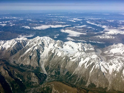
Pyrenees
Mountain range forming the France–Spain border.
The Pyrenees are a mountain range in southwestern Europe that runs along the border between France and Spain. The range stretches nearly 500 kilometers (310 miles) from where it meets the Cantabrian Mountains to Cap de Creus on the Mediterranean coast. Its highest point is the peak of Aneto, which rises to 3,404 meters (11,168 feet) in Huesca, Spain. The main ridge largely serves as a political boundary between Spain and France, with the small principality of Andorra located in between. In the past, both the Crown of Aragon and the Kingdom of Navarre extended across both sides of the range.
The name Pyrenees has roots in Greek mythology. According to the story, Pyrene was a princess. The historian Herodotus mentions Pyrene as a town in Celtic Europe. In the account by Silius Italicus, Pyrene was the virgin daughter of King Bebryx, who ruled in Mediterranean Gaul. The hero Hercules stayed with the king during his labor to steal the cattle of Geryon. While drunk, Hercules raped Pyrene. She later gave birth to a serpent and fled into the woods, afraid of her father’s anger. Alone, she told her story to the trees, which attracted wild beasts that tore her apart. After defeating Geryon, Hercules returned and found her remains. Grieving, he buried her and demanded that the mountains mourn and keep her name. The mountains echoed the name “Pyrene,” and it has been preserved through the ages. Pliny the Elder mentions this story but dismisses it as highly fictional. Other classical sources link the name to the Greek word for fire. The historian Diodorus Siculus wrote that herdsmen once left a fire that burned the entire mountain area, and because the fire raged continuously, the mountains were called the Pyrenees.
Geographically, the Spanish side of the Pyrenees includes the provinces of Girona, Barcelona, Lleida (in Catalonia), Huesca and Zaragoza (in Aragon), Navarra (in Navarre), and Gipuzkoa (in the Basque Country). On the French side, the range covers the départements of Pyrénées-Orientales (also known as Northern Catalonia), Aude, Ariège, Haute-Garonne, Hautes-Pyrénées, and Pyrénées-Atlantiques. The last two contain the Pyrenees National Park. The independent principality of Andorra lies in the eastern part of the range, between the Spanish and French sections.
Physiographically, the Pyrenees are divided into three sections: the Atlantic (or Western), Central, and Eastern Pyrenees. Together, they form a distinct province of the larger Alpine System. In the Western Pyrenees, starting from the Basque Mountains near the Bay of Biscay, the average elevation increases from west to east. The Central Pyrenees stretch eastward from the Somport pass to the Aran Valley and contain the highest peaks: Pico de Aneto at 3,404 meters (11,168 feet) in the Maladeta ridge, Pico Posets at 3,375 meters (11,073 feet), and Monte Perdido at 3,355 meters (11,007 feet). In the Eastern Pyrenees, except for one break at the eastern end of the Pyrénées Ariégeoises, the average elevation stays uniform until a sharp drop near the Albères range at the easternmost part.
Most foothills are on the Spanish side, forming a complex system of ranges that stretch from Spanish Navarre through northern Aragon into Catalonia, nearly reaching the Mediterranean coast, with summits up to 2,600 meters (8,500 feet). At the eastern end on the southern side is a distinct area called the Sub-Pyrenees. On the French side, the main slopes drop steeply, and there are no foothills except in the Corbières Massif in the northeastern corner.
Geologically, the Pyrenees are older than the Alps. Their sediments were first deposited in coastal basins during the Paleozoic and Mesozoic eras. From the Ediacaran to Ordovician periods, the Pyrenees were at the northwest margin of Gondwana, connected to neighboring areas like the Montagne Noire, the Mouthoumet massifs, and southwestern Sardinia. Between 100 and 150 million years ago, during the Early Cretaceous, the Bay of Biscay expanded, pushing present-day Spain against France and compressing large layers of sedimentary rock. This intense pressure and uplift first affected the eastern part and then spread to the entire chain, peaking in the Eocene Epoch. The eastern Pyrenees are mostly granite and gneiss, while the western part has granite peaks flanked by limestone. The chain’s massive, unworn appearance comes from its abundance of granite, which resists erosion, and from weak glacial development. The upper parts contain low-relief surfaces called a peneplain, which formed no earlier than the Late Miocene, likely at height as extensive sedimentation raised the land.
- Location
- Southwestern Europe, along the France–Spain border
- Countries
- France, Spain, Andorra
- Mountain system
- Alpine System
- Geological age
- Paleozoic to Eocene
Lore & Background
In Greek mythology, Pyrene is a princess who gave her name to the Pyrenees. According to Silius Italicus, she was the virgin daughter of King Bebryx, by whom the hero Hercules was given hospitality during his quest to steal the cattle of Geryon. Hercules, drunk and lustful, raped his host's daughter. Pyrene gave birth to a serpent and ran away to the woods, where wild beasts tore her to pieces. After his victory, Hercules found her lacerated remains, laid her to rest, and demanded that the surrounding geography mourn and preserve her name. Pliny the Elder connects the story to Lusitania but rejects it as highly fictional. Other classical sources derived the name from the Greek word for fire, as Diodorus Siculus recounts that herdsmen left a fire that consumed the whole area, burning the surface of the earth and giving the mountains their name.
Reader's Guide
The Pyrenees are significant as a natural and political boundary between France and Spain, with the independent principality of Andorra located within the range. Physiographically, they are divided into three sections: Atlantic, Central, and Eastern. The Central Pyrenees contain the highest summits, including Aneto, Posets, and Monte Perdido. The range is older than the Alps, with sediments first deposited during the Paleozoic and Mesozoic eras. Intense compression during the Early Cretaceous and Eocene epochs uplifted the chain. The eastern part consists largely of granite and gneiss, while the western part has limestone layers. Notable landscape features include the absence of great lakes, rare high passes, numerous mountain torrents called gaves, and cirques such as the Cirque de Gavarnie. Low passes are lacking, so major roads and railroads run only near sea level at the western and eastern ends. The range has provided metallic ores, coal, lignite, talc, and marble quarried since Roman times.
Did You Know?
- The Pyrenees are older than the Alps, with sediments first deposited during the Paleozoic and Mesozoic eras.
- The open pit of Trimoun near Luzenac is one of the greatest sources of talc in Europe.
A Border Carved in Stone
The Pyrenees stretch roughly five hundred kilometres across southwestern Europe, running from their junction with the Cantabrian Mountains all the way to the Mediterranean tip at Cap de Creus. For centuries, this main crest has served as a natural political boundary, dividing France to the north from Spain to the south, with the tiny principality of Andorra tucked into the eastern stretch between the two. On the Spanish side, the mountains fall under seven provinces spanning Catalonia, Aragon, Navarre, and the Basque Country, while the French side is divided among six départements, two of which shelter the Pyrenees National Park. The political geography is layered with history: the old Crown of Aragon and the Kingdom of Navarre once held territory on both flanks of the range, meaning the mountains were once internal features within single kingdoms rather than international borders.
Ancient Bones of the Earth
Long before the Alps rose to their present grandeur, the Pyrenees were already taking shape. Their foundational sediments were laid down in shallow coastal basins during the Paleozoic and Mesozoic eras, when the region sat along the northwestern margin of the supercontinent Gondwana. The resulting uplift first struck the eastern segment of the chain and then rolled progressively westward, reaching its climax in the Eocene Epoch. The rock itself tells the story of this violence. The eastern Pyrenees are built largely from granite and gneissose, while the western peaks of granite are ringed by limestone layers. That abundance of hard granite has given the range its massive, unworn silhouette, resisting erosion far better than softer rock and limiting the development of glaciers. Even the high peneplain surfaces visible today date back no earlier than the Late Miocene, when extensive sedimentation raised the local base level.
The Girl Who Became a Mountain
In Greek myth, the Pyrenees bear the name of a young woman whose tragedy was written into the landscape itself. Silius Italicus tells of Pyrene, the virgin daughter of Bebryx, a king in Mediterranean Gaul who hosted the hero Hercules during his famous quest to steal the cattle of Geryon. Drunk and driven by lust, Hercules violated the sacred bond of hospitality and assaulted his host's daughter. Pyrene, who bore a serpent as the child of that violation, fled into the wilderness terrified of her father's wrath. There she poured her grief to the trees, drawing the attention of wild beasts that tore her apart. When the sober Hercules returned and found her mangled remains, he was seized by remorse. He laid her to rest with tenderness and commanded the surrounding geography to join in mourning, crying out her name until the rock-cliffs and beast-haunts echoed it back forever. Pliny the Elder acknowledged the tale but dismissed it as highly fictional. Other classical writers traced the name instead to the Greek word for fire, citing a story from Diodorus Siculus in which a herdsmen's abandoned blaze consumed the entire mountain area for days, scorching the earth and earning the range its fiery name.
A Landscape of Torrents and Silence
The Pyrenees present a landscape that deliberately defies the Alpine template. Where the Alps are studded with great glacial lakes filling their lateral valleys, the Pyrenees are conspicuously almost entirely without them. Usable mountain passes are rare and sit at high elevations, making traversal genuinely difficult. Instead, the range is defined by water in motion: a dense network of mountain torrents, locally called gaves, plunges down steep slopes to form waterfalls of a height surpassed in Europe only by those of Scandinavia. Physiographically the chain divides into three zones. The Western or Atlantic Pyrenees begin at the Basque Mountains near the Bay of Biscay, with elevations climbing gradually eastward. The Eastern Pyrenees maintain a remarkably uniform mean elevation until a sudden drop at the Albères.
Frequently Asked Questions
What are Pyrenees's powers/role?
Pyrenees acts as the principal natural barrier and political boundary separating France from Spain, with its main ridge largely tracing the international border. It also shelters Andorra within its folds, making the range a key geopolitical crossroads in the region.
How does Pyrenees's story end?
Pyrenees's geological narrative runs from the Paleozoic era through the Eocene, meaning its foundational strata were deposited hundreds of millions of years ago. The range still stands today, though its peaks continue to erode gradually over deep geological time.
Why is Pyrenees important?
Pyrenees is a major component of the Alpine System and has shaped the political geography of southwestern Europe for centuries, as both the Crown of Aragon and the Kingdom of Navarre once extended across both sides of the range. It remains a defining natural landmark for France, Spain, and Andorra alike.
More in Mountain Ranges And Massifs 1-24
Spotted an error? Know more?
This is a living reference — every entry is fact-audited, and reader corrections feed straight into our audit queue. Suggest an edit · See this site's audit record