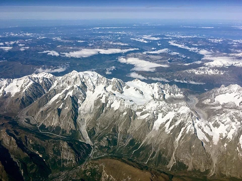
Canadian Rockies
Canadian segment of the North American Rocky Mountains.

Most of Alberta's mountains are found on the western edge of the province, consisting of the eastern slopes of the Canadian Rockies, which run through the province from Alberta's mid-point to its southern border with the United States. Other elevated spots can be found in the Caribou Mountains and the Cypress Hills. The peaks of the Canadian Rockies are majestic, many of them reaching a height of more than three kilometres above sea level. Alberta's southwestern boundary is traced on the Continental Divide, along the high ranges of the Rocky Mountains, and many peaks are located on the Alberta–British Columbia border. The peak of Mount Columbia, within Jasper National Park, is the highest point in Alberta, second highest in the Canadian Rockies and 28th highest in Canada.
- Highest peak
- Mount Columbia (3,747 m; 12,293 ft)
- Second-highest peak
- Mount Columbia (3,747 m; 12,293 ft)
Lore & Background
The Caribou Mountains are located in the northern extremity of Alberta, forming an elevated plateau in the northern plains and wetlands. They reach an altitude of 1,030 m, almost 700 m higher than the surrounding area. While not considered mountains, the Cypress Hills, located in the south-eastern corner of Alberta, extending into Saskatchewan, constitute the highest terrain in Canada between the Rocky Mountains and Labrador. They reach a maximum elevation of 1,468 m, 600 m above the surrounding prairie. The Rockies are crossed through east–west alpine passes, such as Abbot Pass, Crowsnest Pass, Kicking Horse Pass, Kiwetinok Pass, Sunwapta Pass, Weary Creek Gap, and Yellowhead Pass.
Reader's Guide
The highest peaks in Alberta include Mount Columbia at 3,747 m (12,293 ft), Twin Peaks massif at 3,684 m (12,087 ft), Mount Alberta at 3,619 m (11,873 ft), Mount Assiniboine at 3,616 m (11,864 ft), Mount Forbes at 3,612 m (11,850 ft), Mount Temple at 3,543 m (11,624 ft), Mount Brazeau at 3,525 m (11,565 ft), Snow Dome at 3,520 m (11,549 ft), Mount Kitchener at 3,505 m (11,499 ft), and Mount Lyell at 3,504 m (11,496 ft). The ranges of the Canadian Rockies in Alberta include Bare Range, Blairmore Range, Blue Range, Bosche Range, Brazeau Range, Caribou Mountains, Clark Range (Border Ranges), Colin Range, Elk Range, Fairholme Range, Fiddle Range, Fisher Range, High Rock Range, Highwood Range, Jacques Range, Kananaskis Range, Livingstone Range, Maligne Range, Massive Range, Miette Range, Misty Range, Opal Range, Palliser Range, President Range, Queen Elizabeth Ranges, Ram Range, Sawback Range, Slate Range, De Smet Range, Spray Mountains, Valley of the Ten Peaks, Vermilion Range, Victoria Cross Ranges, Waputik Range, and Winston Churchill Range.
Did You Know?
- Mount Columbia is the highest point in Alberta, second highest in the Canadian Rockies, and 28th highest in Canada.
- The Caribou Mountains reach an altitude of 1,030 m, almost 700 m higher than the surrounding area.
- The Cypress Hills reach a maximum elevation of 1,468 m, 600 m above the surrounding prairie.
- The Cypress Hills constitute the highest terrain in Canada between the Rocky Mountains and Labrador.
- Many peaks in the Canadian Rockies are located on the Alberta–British Columbia border.
Frequently Asked Questions
Who is Canadian Rockies?
The Canadian Rockies are the Canadian portion of the North American Rocky Mountains, forming the easternmost segment of the Canadian Cordillera. They stretch from the Liard River valley in northern British Columbia southward to the 49th parallel at the U.S. border.
What are Canadian Rockies's powers/role?
The range is celebrated for its towering summits, headlined by Mount Robson at 3,954 metres and Mount Columbia at 3,747 metres, making it one of Canada's highest-elevation ranges. It also acts as a critical watershed, feeding headwater streams that supply water far downstream.
How does Canadian Rockies's story end?
The range's southern terminus sits at the Canada–United States border along the 49th parallel north. Its other boundaries are the Canadian Prairies to the east, the Rocky Mountain Trench to the west, and the Liard River to the north.
Why is Canadian Rockies important?
Four adjacent national parks—Banff, Jasper, Kootenay, and Yoho—plus three British Columbia provincial parks were jointly inscribed as a UNESCO World Heritage Site in 1984. The range also anchors five national parks, making it a central pillar of Canadian wilderness conservation.
What is Canadian Rockies made of?
The bedrock is predominantly shale and limestone, sedimentary layers that were originally laid down in ancient marine basins before tectonic uplift raised them into today's dramatic peaks. This composition gives the range its characteristic stratified cliffs and rounded, eroded ridgelines.
More in Mountain Ranges And Massifs 1-24
Elsewhere in the Mountain Ranges And Massifs universe
Spotted an error? Know more?
This is a living reference — every entry is fact-audited, and reader corrections feed straight into our audit queue. Suggest an edit · See this site's audit record